Business & Tech
Norcross Weighs in on Town Center Plan
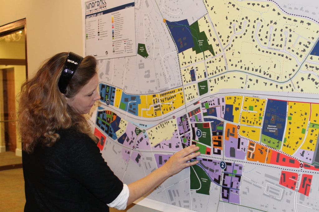
The first draft of the future downtown plan was introduced at Wednesday's town hall meeting.

The first draft of the Norcross Town Center Downtown Plan was revealed in Wednesday's town hall meeting and brought much discussion from the community.
Engineering firm Pond and Co. presented the plan, which is an update on the . The firm and the city of Norcross have been working together since last November to create a better vision for the future of downtown Norcross.
Concentrating on the area between Langford Road and Jimmy Carter Boulevard, the team laid down a blueprint for roads, greenspace, residences, local and national retail, and everything in between.
Interested in local real estate?Subscribe to Patch's new newsletter to be the first to know about open houses, new listings and more.
Two town hall meetings were so that the community could weigh in on the plans, too.
At Wednesday's meeting, Project Manager Joel Reed revealed two maps, one with a proposal for transportation and the other for land-use. As a guideline for the downtown area for the next twenty years, the maps showed every specific detail, from where a bike path would go to what street would house a five-story midrise office.
Interested in local real estate?Subscribe to Patch's new newsletter to be the first to know about open houses, new listings and more.
One of the plan's recommendations that many agreed with was constructing a public space/plaza between and Buford Highway. The plan would open up the area and let visitors traveling along the highway see that downtown Norcross exists.
Another item to note was the concept of mid-rise mixed use buildings (three to five floors) along the south side of Buford High and Mitchell Road, next to Cemetery Field. Resident Ranae Ramsay said she favors the idea, especially since it could mean a Publix or another supermarket could move in, something many residents want.
The same type of mixed-use didn't bode well with citizens when it was proposed along College Street, though. Reed explained it would add to the town center entrance when looking from Buford Highway, but many community members thought the five-story concept didn't represent historic downtown at that particular location.
"I think it's very out of place there," said resident Michelle Crofton.
For transportation, most people agreed with the plans of adding more bike trails and walking paths. A multi-use trail for Holcomb Bridge Road had people nodding their heads, and no one voiced disapproval on adding a pedestrian loop that would connect corners of downtown with Lillian Webb.
A median with streetscaping for Buford Highway was also on the draft, which is currently going through paperwork to being built, according to Pond and Co.
Residents Danielle Hartley and Theo Tuerke said they don't like the idea of having sharrows, a painted sign on pavement simply reminding drivers to share the road, all over downtown. Hartley explained that with a busy road like Holcomb Bridge, bikes would just cause more traffic during the morning and afternoon commutes.
, the plans suggested building a pedestrian tunnel underneath the tracks for safer crossing, but Reed and his team recommended that the intersection needs a separate study to make an appropriate plan.
The next town hall meeting will be the last gathering concerning the Town Center Downtown Plan, which will detail the final draft. The meeting will be held at 7 p.m. Wednesday, May 24, at the .
For more information on the Town Center Plan, visit aplacetoimagine.com/creating-community.
Get more local news delivered straight to your inbox. Sign up for free Patch newsletters and alerts.


